
 Interactive Radar |  NBC 5 S-Band |  Dallas County |  Tarrant County |
 Collin County |  Denton County |  Ellis, Johnson Co. |  Rainfall Totals |
S Band Radar & Maps | Forecast | Weather Alerts
Traffic | Send Us a Photo/Video | Live Cams
Monday presents a real concern for widespread severe weather for portions of northwestern Texas and up into Oklahoma where several cities are in the "high risk" category including Wichita Falls, Vernon, Childress, Seymour and Snyder in Texas and Lawton, and Oklahoma City in Oklahoma; it's the first time the area has been under a "high risk" warning since 2017.
In this "high risk" area, a violent tornado outbreak is possible, including the threat for long-track, devastating tornadoes.
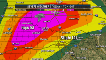
For North Texas, our risk of severe weather today is highly "conditional." This means storms may or may not develop and become severe. The chance is certainly there, but not all of the necessary ingredients are in place.
Winds are expected to increase early Monday afternoon and remain gusty overnight. A Wind Advisory is in effect until 1 a.m. Tuesday as sustained south winds are expected to be between 20 mph and 30 mph with gusts to 40 mph -- winds at that speed could cause damage unsecured outdoor items. Also, driving may become difficult on east-west roads, especially for high-profile vehicles. The advisory impacts the following counties: Bell, Bosque, Collin, Comanche, Cooke, Coryell, Dallas, Denton, Eastland, Ellis, Erath, Falls, Grayson, Hamilton, Hill, Hood, Jack, Johnson, Lampasas, McLennan, Milam, Mills, Montague, Palo Pinto, Parker, Somervell, Stephens, Tarrant, Wise, Young.
The three main ingredients needed for severe weather are instability, moisture and lift. The "lift" is essentially the trigger to get storms to develop. This is the ingredient that is questionable.
However, since our instability is going to be very high, the possibility of seeing severe weather is certainly present this afternoon.
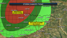
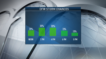
The timing for isolated severe storms in North Texas is this afternoon between 12 p.m. and 6 p.m. These storms will be isolated and not for everyone. But, if they develop, they could pose a risk for tornadoes and high winds.
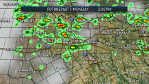
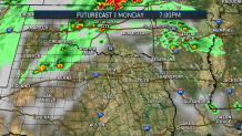
As the storms out west continue to develop during the day and into tonight, they will likely merge into a solid line. This line will likely move into North Texas overnight and is expected to impact DFW Tuesday morning.
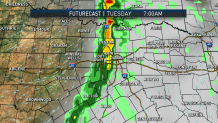
Strong winds will be the main concern, along with heavy downpours. It looks like this will impact the morning commute for Tuesday.
After the line clears tomorrow, the pattern looks quiet for several days.
The latest video forecast from NBC DFW's team of Weather Experts will appear in the player above. Keep up with the latest changes to the weather by downloading the NBC DFW smartphone App for iOS and Android!
Weather Connection
Connecting you with your forecast and all the things that make North Texas weather unique.


Read the latest forecast information from NBC 5's team of Weather Experts here.
- Stay Connected. Download the NBC DFW App
- Set your push alert preferences.
- Charge your phones and tablets so that if you lose power you can still watch live weather coverage in the App.
| Stay Safe During a Hail Storm At Home?
Outdoors?
Driving?
|
