
There is a 50-55% chance of La Niña developing this fall and lasting through the winter, prompting the National Oceanic and Atmospheric Administration to issue a La Niña Watch.
The forecast is based on the current conditions of the tropical Pacific Ocean and computer model guidance.
What is La Niña?
La Niña refers to persistent colder-than-normal sea surface temperatures across the central and eastern equatorial Pacific. La Niña is part of the phenomenon known as the El Niño Southern Oscillation. An oscillation is a motion that repeats itself over a period of time. Its opposite counterpart is El Niño, which has warmer-than-normal sea surface temperature anomalies across the same equatorial waters.
What does this mean for North Texas Weather?
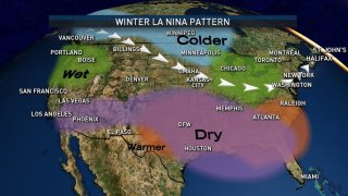
It means warmer-than-normal temperatures and below-normal precipitation this fall and winter. Drought is more likely to develop and/or intensify with an increased number of days with fire weather threats.
Heavy rain could still occur, but not as often. Although the upcoming cold season is likely to be warmer than normal overall, brief periods of very cold weather will still be possible. La Niña weather patterns are a generalization of what we could see weather-wise.
Local
The latest news from around North Texas.


There are many factors other than La Nina that can affect our weather during the cold season; but since many of these features can't be predicted very well beyond a couple of weeks, they are not considered for seasonal outlooks.