
Severe thunderstorms are expected late Monday afternoon and into the evening in North Texas bringing a chance for large hail and damaging wind.
Some of the storms could vary between strong to severe as a dryline and cold front move through North Texas.
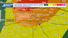
The Storm Prediction Center has placed much of North Texas under an Enhanced Risk (level 3 out of 5) for severe storms with a Moderate Risk (level 4 out of 5) for northwest North Texas. Storm timing in the Metroplex is expected to be between 4 p.m. to 10 p.m. with activity expected in Tarrant County at about 7 p.m.
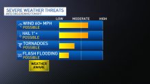
The primary concerns are large hail and damaging winds (wind 60 mph+). While the tornado threat is low, it's not zero.
Get DFW local news, weather forecasts and entertainment stories to your inbox. Sign up for NBC DFW newsletters.
Storms drop hail from quarter-size to nearly tennis ball size on North Texas April 1, 2024
As the storms built west of the Metroplex and moved east, the National Weather Service warned of very large hail up to baseball-sized and wind gusts above 85 mph. Hail of that size could injure people and animals outdoors and damage roofs, siding, windows and vehicles.
Make sure you stay "weather aware" on Monday afternoon and evening and continue to check back for additional updates.
WATCHES AND WARNINGS
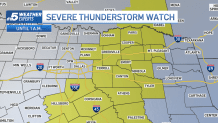
A new Severe Thunderstorm Watch has been issued until 1 a.m. for areas east of DFW into East Texas.
NBC 5 Weather Experts


CONTINUING WEATHER COVERAGE
Stay up to date with the latest weather forecast from NBC 5's team of Weather Experts by clicking here or by watching the video below.

Be prepared for your day and week ahead. Sign up for our weather newsletter.
