
S Band Radar & Maps | Forecast | Weather Alerts
Traffic | Send Us a Photo/Video | Live Cams
It's another cold start Wednesday with temperatures falling into the upper 20s for much of the area.
The official temperature recorded at Dallas-Fort Worth International Airport both Monday and Tuesday dropped to 21 degrees — just one degree shy of tying the record low of 20.
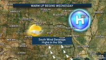
Temperatures dropped into the upper 20s overnight into Wednesday, but the worst of the cold air is behind us. A warming trend begins Wednesday afternoon.
We are now into March, which is the time of year we start to see the threat for thunderstorms (and even severe weather) on the increase.
In classic, "just wait a few minutes and the weather will change," Texas weather parlance, we’ll go from the deep freeze Monday and Tuesday to thunderstorms by Saturday.
A storm system will move through the Four Corners late this week. While we will have a chance for thunderstorms Saturday, the timing of the storm system moving through our area is not favorable for widespread severe weather.
Local
The latest news from around North Texas.

A few strong to marginally severe storms may take place during the first half of Saturday. By Saturday afternoon, the dryline will be east of DFW and the threat for storms will quickly move into East Texas for the rest of the day.
There will be another chance for thunderstorms early next week as well. Please stay WEATHER AWARE!
Get the latest forecast information from NBC 5's team of Weather Experts here.
 Interactive Radar |  NBC 5 S-Band |  Dallas County |  Tarrant County |
 Collin County |  Denton County |  Ellis, Johnson Co. |  Rainfall Totals |
