
S Band Radar & Maps | Forecast | Weather Alerts
Traffic | Send Us a Photo/Video | Live Cams
The jet stream pattern has shifted into a position that is favorable for dry weather for much of North Texas for the coming days. A large ridge of dry high pressure will be firmly entrenched over the Southeast United States. At the same time a chilly area of low pressure is over the Rockies. North Texas is in the middle of these opposite weather systems.
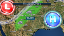
The battle ground between the two systems will be where the best chance of showers and thunderstorms will occur through Friday. That will be parts of West and Northwest Texas, north into parts of Oklahoma and the Central Plains.
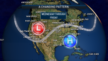
With the highest chance of storms remaining mostly to the west and north of North Texas, our forecast looks mainly dry through the Memorial Day weekend.
Local
The latest news from around North Texas.


The latest video forecast from NBC DFW's team of Weather Experts will appear in the player above. Keep up with the latest changes to the weather by downloading the NBC DFW smartphone App for iOS and Android!
Read the latest forecast information from NBC 5's team of Weather Experts here.
- Stay Connected. Download the NBC DFW App
- Set your push alert preferences.
- Charge your phones and tablets so that if you lose power you can still watch live weather coverage in the App.
| Stay Safe During a Hail Storm At Home?
Outdoors?
Driving?
|
 Interactive Radar |  NBC 5 S-Band |  Dallas County |  Tarrant County |
 Collin County |  Denton County |  Ellis, Johnson Co. |  Rainfall Totals |
