

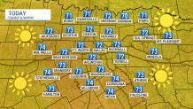
The final days of January have been spring-like with highs in the 70s and sun filled skies. Today will be another pleasant day with highs in the low 70s.
A few weeks ago DFW had a record low of 11 degrees with a stretch of about 80 hours below freezing. With a few 70-degree days happening now, it is no wonder everyone is thinking spring! Not so fast...
The first day of spring is not until March 19. The normal high during the month of February is 60.9 degrees, normal low is 40.1 degrees. Historically February and even March have featured some significant winter weather events in North Texas. Here are are few:
Get DFW local news, weather forecasts and entertainment stories to your inbox. Sign up for NBC DFW newsletters.
During a severe arctic outbreak, multiple rounds of snowfall occurred. Event totals of 6 to 8 inches were widespread in areas east of the I-35 corridor as well as across portions of Northwest Texas. The 5-inch tally at DFW Airport was the highest event total in more than a decade, and Waco's 4.6 inches was the greatest amount in nearly 40 years.
Local
The latest news from around North Texas.

Widespread snow resulted in measurable amounts regionwide. From northern portions of the Dallas/Fort Worth Metroplex into Northeast Texas, event totals were 5 to 6 inches.
Heavy snow fell from the Big Country into Texoma. The greatest event totals were from Breckenridge (6 inches) to Decatur (7 inches).
Snow began in Central Texas during the evening hours of February 3. The snow spread north overnight, impacting nearly all of North Texas. Snow continued in Northeast Texas into the evening hours of February 4.
Dallas Love Field measured 5.1 inches for the event. Totals of 6 inches or more could be found in Collin County, and from Corsicana to Terrell and Canton. The heaviest amounts were 7 to 8 inches, from Emory and Sulphur Springs to Mineola and Mount Pleasant.
Heavy rain accompanied a strong arctic front. The precipitation transitioned to heavy sleet thunderstorms during the early morning hours of February 1. Winds gusted over 50 mph at DFW Airport with heavy sleet. The precipitation changed to snow before ending, accumulating 6 to 7 inches of frozen precipitation in Graham and Olney.
Freezing temperatures are also not uncommon in February and March. The average date of the last freeze is March, 12. The latest freeze on record was April 13. North Texas averages 6 freezes during the month of February and 1-2 in March.
Long-range forecast models put out by the Climate Prediction Center keep North Texas temperatures warmer than normal through Valentine's Day.
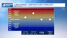
The projection for the rest of the season into early spring is for normal temperatures for North Texas. Meaning that another round of freezing temperatures is possible.
