Live video from the NBC 5 Weather Center will appear in the player above. At times the stream will change from live radar to live coverage.
What to Know
- Though the tornado threat is not zero, flooding remains the largest threat with these waves of storms.
- Flash Flood Watch continues for nearly four dozen North Texas counties into Wednesday morning.
- Street flooding to be a significant concern through the week.
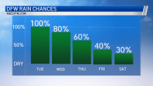
With more rain on the way, the threat for flooding continues across North Texas Tuesday.
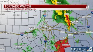
A Tornado Watch is in effect for Freestone, Anderson, Leon, Milam and Robertson counties until 9 p.m.
Get DFW local news, weather forecasts and entertainment stories to your inbox. Sign up for NBC DFW newsletters.
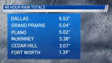
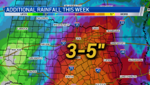
A Flash Flood Watch (details below) remains in effect until Wednesday evening. Some locations have already received nearly 6 inches of rain over the past couple of days. An additional 3 to 5 inches is possible before the end of the week. That said, there will also be extended periods of dry weather each day as well.
North Texas Weather
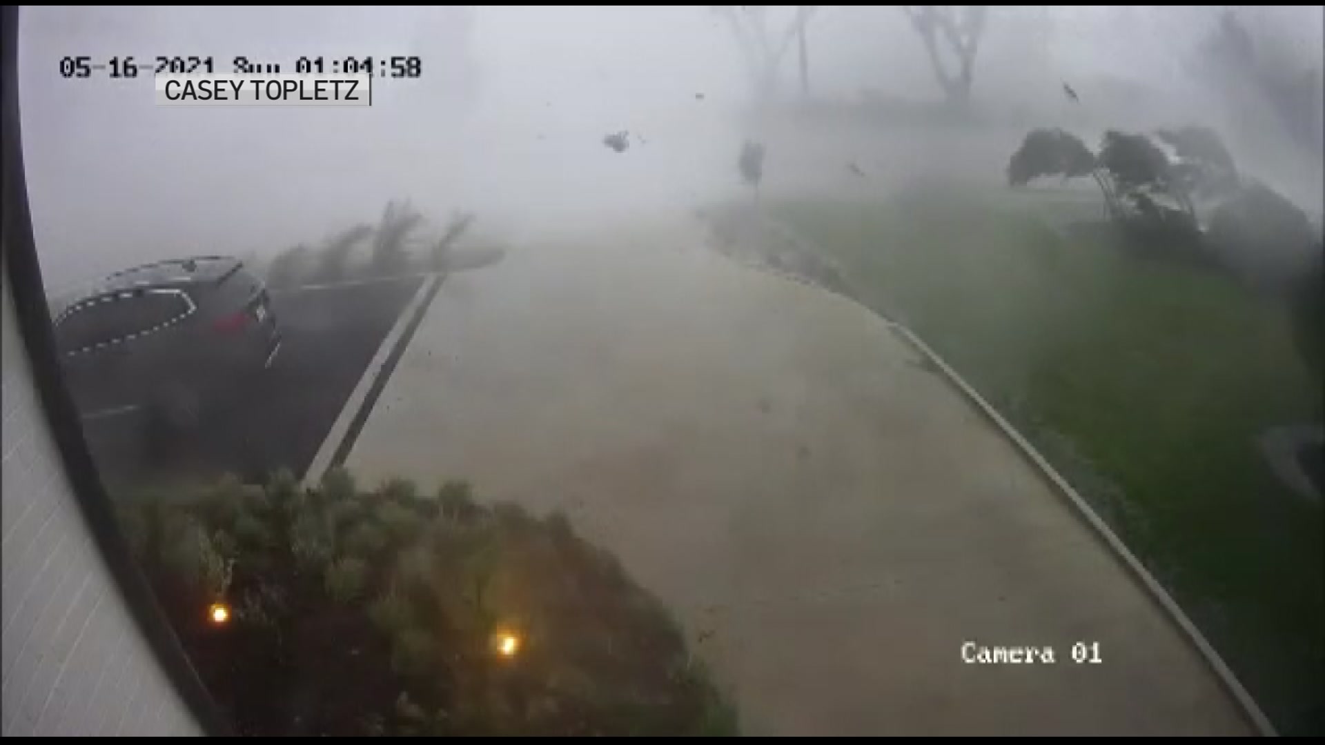
While flooding will be the primary concern over the next 24 hours, hail and damaging winds will also be possible with storms that manage to become severe.
The timing for severe weather is generally late Tuesday, primarily Tuesday evening and into the overnight hours.
The energy driving out of West Texas will help initiate a line of strong to severe storms Tuesday night in North Texas. The tornado threat appears low, but not zero.
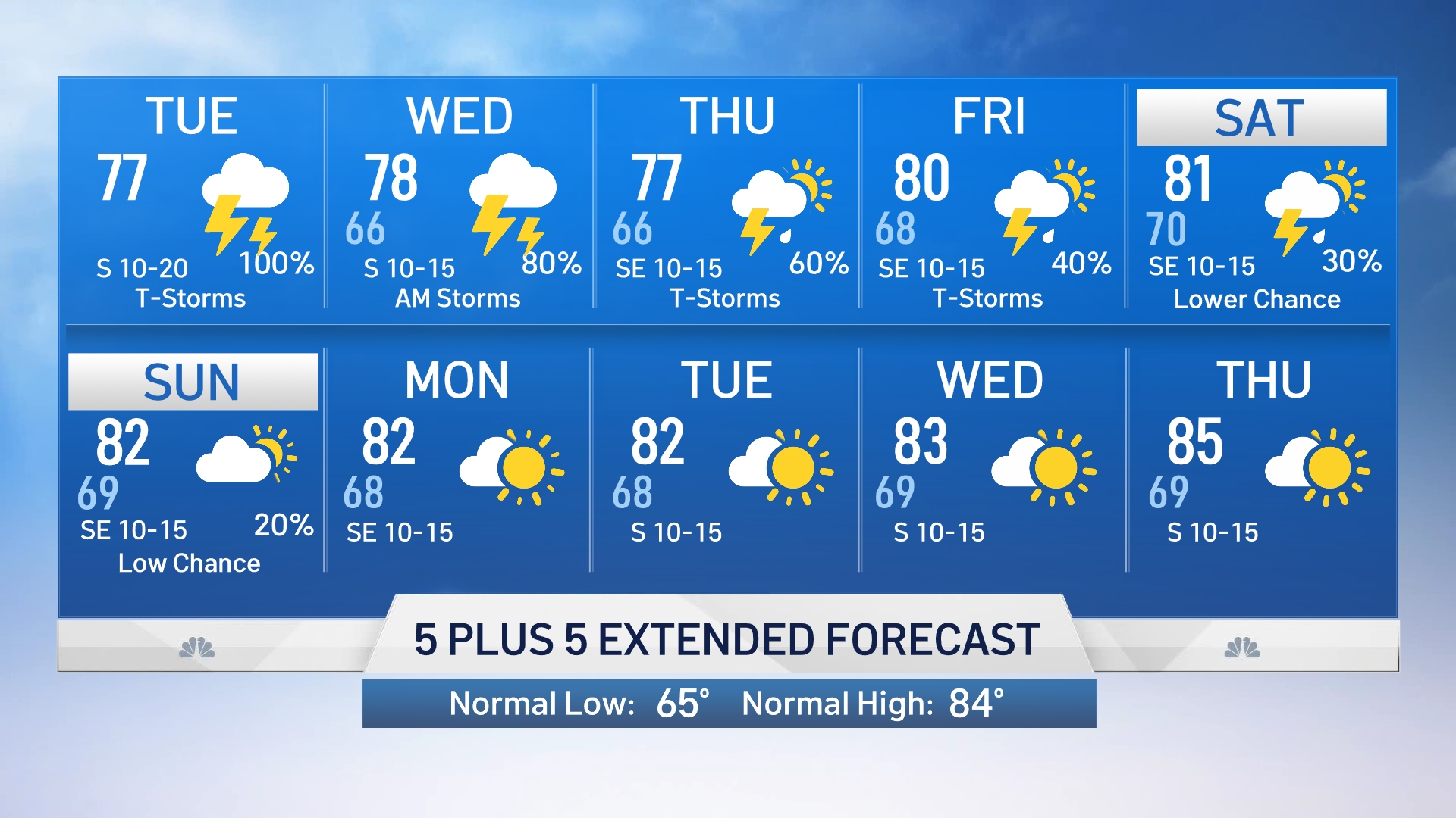
Wednesday will likely begin with leftover showers and thunderstorms in the morning. Another round or two of storms is possible Thursday and Friday as well.
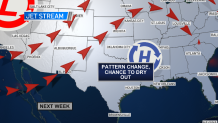
Rain chances appear lower this weekend, but we still cannot rule out a couple of hit-and-miss storms. Next week, the models are hinting at a shift in the jet stream which will bring dry weather back to North Texas.
Flash Flood Watch and River Flood Warning
Over the weekend the National Weather Service issued a Flash Flood Watch that will remain in effect until Wednesday morning for much of the area and a River Flood Warning has also been issued for several North Texas counties.
Flooding may occur in urban and poor drainage areas. Heavy rainfall may also cause flooding of creeks, streams, and rivers.
The Flash Flood Watch is for portions of the following counties: Anderson, Bell, Bosque, Collin, Comanche, Cooke, Coryell, Dallas, Delta, Denton, Eastland, Ellis, Erath, Falls, Fannin, Freestone, Grayson, Hamilton, Henderson, Hill, Hood, Hopkins, Hunt, Jack, Johnson, Kaufman, Lamar, Lampasas, Leon, Limestone, McLennan, Milam, Mills, Montague, Navarro, Palo Pinto, Parker, Rains, Robertson, Rockwall, Somervell, Stephens, Tarrant, Van Zandt, Wise and Young.
Flash Flooding Dangers


Be sure to stay weather aware and have multiple ways to receive warnings.
CONTINUING WEATHER COVERAGE
Stay up to date with the latest weather forecast from NBC 5's team of Weather Experts by clicking here or by watching the video below.