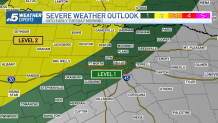
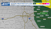
A powerful storm system is moving out of the Rockies and into the Central and Southern Plains. This storm system will bring a threat of severe weather into North Texas.
The severe weather risk stretches all the way from Nebraska down to North Texas.
The main concern for tornadoes will be in Nebraska and Kansas by late afternoon and evening.
Here in North Texas, the main focus for storms will be to the west and northwest of DFW.
Get DFW local news, weather forecasts and entertainment stories to your inbox. Sign up for NBC DFW newsletters.
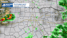
While widespread and numerous thunderstorms are not expected, a couple of isolated storms could produce large hail and damaging winds.
Hail sizes could be golf ball to baseball size in the strongest storms.
Again, this is mainly expected to be west and northwest of DFW.
Local
The latest news from around North Texas.


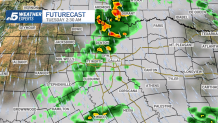
As the overnight hours wear on, any storms that develop are expected to gradually weaken as they move eastward.
Even still, a couple may be strong enough to survive into early Tuesday morning. Hail and gusty winds will be the primary threat.
By midday Tuesday, the storm threat looks to be well east of here. Sunshine and very warm weather will take hold for a few days before more storm chances return late in the week.