While we have another day of intense heat here in North Texas, a tropical storm will be moving onshore down in South Texas Tuesday.
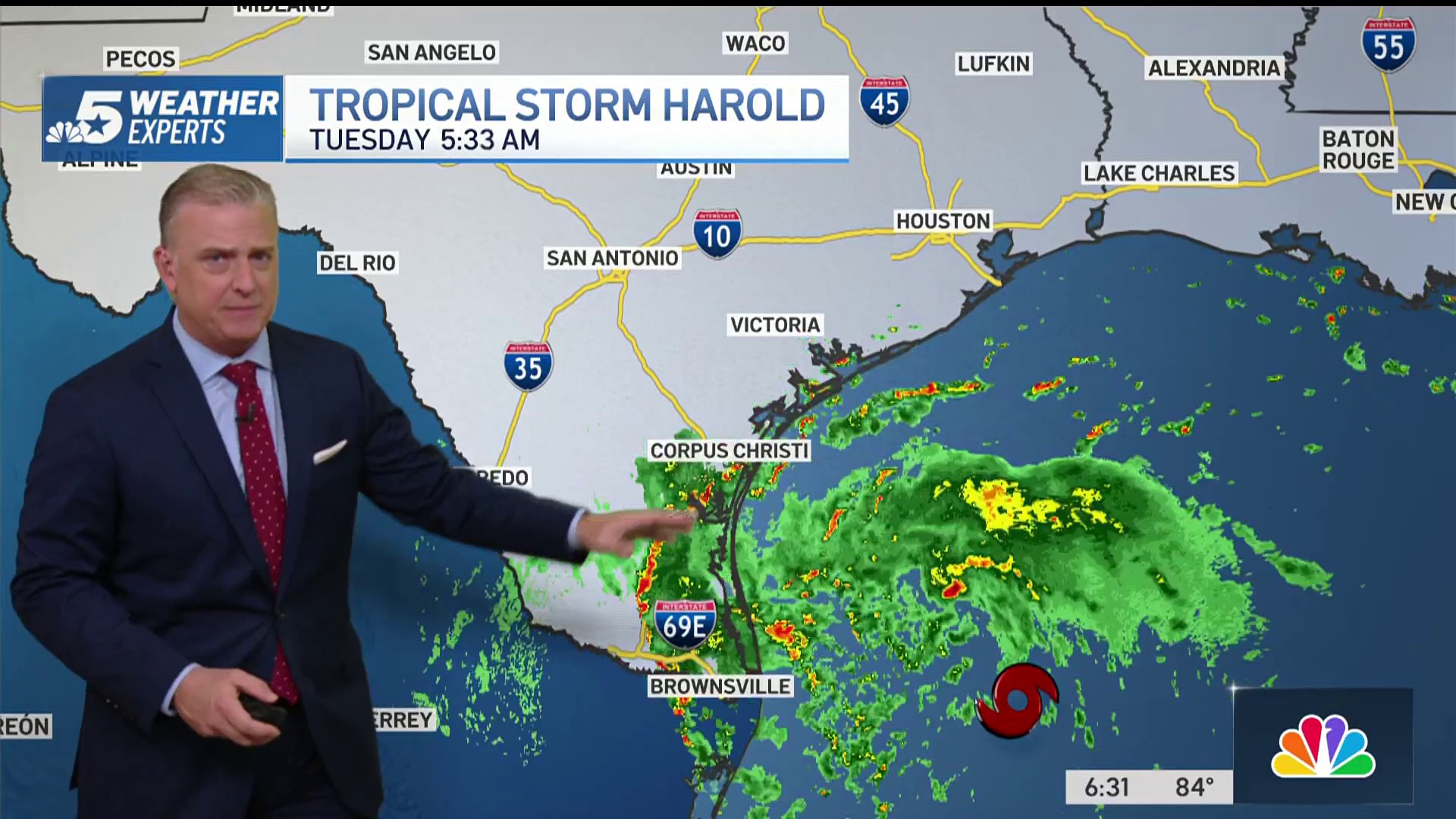
Tropical Storm Harold made landfall at about 10 a.m. Tuesday near South Padre Island and spread heavy rain along the coast from Corpus Christi to Brownsville. Some locations were expected to receive 3-5 inches of rain, which could result in localized flooding. Winds will be below tropical storm force, around 40 mph, which could still cause some power disruptions, but widespread outages are unlikely.
All of the rain associated with the storm is expected to stay well south of the Dallas-Fort Worth area and Central Texas and will mainly impact the Rio Grande Valley.

Get DFW local news, weather forecasts and entertainment stories to your inbox. Sign up for NBC DFW newsletters.
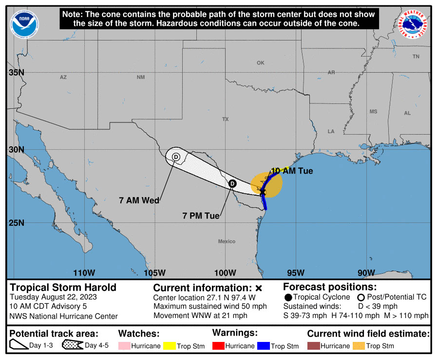
Harold is moving toward the west-northwest near 21 mph and the NWS said the storm is expected to continue following that track inland over southern Texas and northern Mexico. Steady weakening is expected and Harold is expected to become a tropical depression later Tuesday.
The NWS said Tropical Storm Harold is expected to produce rainfall amounts of 2 to 4 inches, with isolated higher amounts of 6 inches, across South Texas through early Wednesday.
The storm is also expected to hit portions of northern Coahuila and northern Nuevo Leon in Mexico.
Those in the path of the storm are warned to prepare for emergencies including power outages, excessive rainfall, dangerous flooding, wind damage and the possibility of tornadoes.
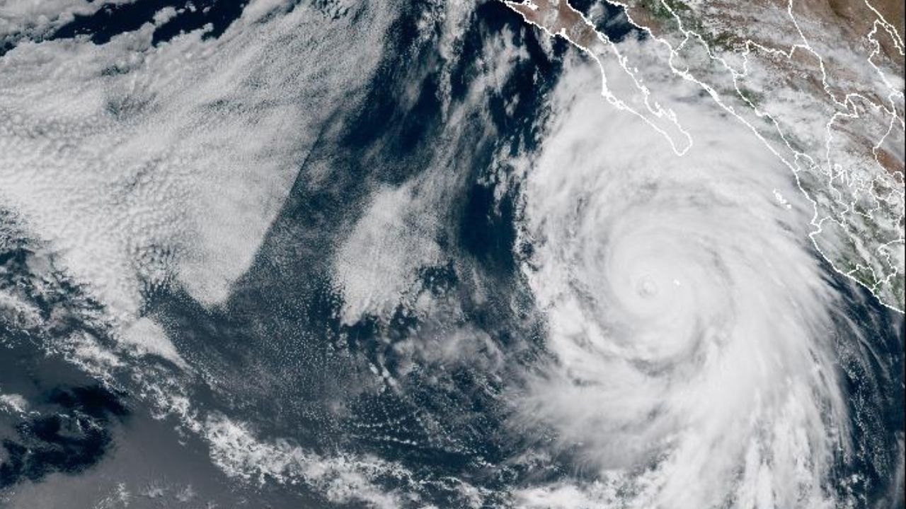
Tropical Storm Franklin was expected to make landfall on the island of Hispaniola Wednesday and bring heavy rains of up to 10 inches (25 centimeters) to Haiti and the Dominican Republic, with up to 15 inches (38 centimeters) in isolated areas. Franklin is expected to turn north into the Atlantic and not enter the Gulf of Mexico.
HAROLD BRINGS RAIN, COOLER TEMPS TO SOUTH TEXAS
Thousands of homes and businesses in the South Texas city of Corpus Christi are without power Tuesday after the state's first tropical storm of the hurricane season made landfall, bringing strong winds, welcome rain and cooler temperatures following months of hot, dry weather.
Tropical Storm Harold, which never reached hurricane status, made landfall about 10 a.m. near South Padre Island on the Texas Gulf coast, according to National Weather Service meteorologist Joshua Schroeder in nearby Brownsville.
"Although it formed over the warm waters of the Gulf of Mexico, it moved so quickly it just didn't have time to intensify into a hurricane," Schroeder said.
Schroeder said the rain is mostly welcome.
"There's pockets of heavy rainfall, 2 to 4 inches and isolated areas are seeing up to 6 inches," Schroeder said. "But we've been very dry down here in South Texas and this (rain) will be beneficial."
Dry conditions have prevailed in South Texas for months and in some areas for years, according to Cory Mottice, the Warning Coordination Meteorologist for the NWS in Corpus Christi.
Corpus Christi has received about 3 inches of rain so far and it has been in a drought for about two months, Mottice said, referring to data from the U.S. Drought Monitor. Over in Webb County, which includes the city of Laredo, which has been in a drought for two years, little more than a quarter of an inch of rain fell, he said.
The National Weather Service recorded winds of up to 50 mph in Corpus Christi.
The storm knocked out power for about 11,000 customers in the city of around 300,000 people about 150 miles north of the U.S.-Mexico border, and customers in Laredo, Aransas Pass, Port Lavaca, and San Benito were also experiencing outages, according to AEP Texas.
The power company has deployed some 1,500 workers across South Texas to repair service lines, spokesperson Omar Lopez told The Associated Press.
John Cangialosi, senior hurricane specialist with the National Hurricane Center in Miami described Harold as a mid-grade tropical storm.
"This is not a minor event, but not a major event for the area," Cangialosi said. "It is moving quickly, so it's not going to produce copious amounts of rainfall and flooding, and there are going to be gusty winds, but we're not going to see hurricane-force winds."
Late morning, the storm was moving northwest across the mainland at about 20 mph.
In Mexico, 4 to 6 inches of rain was forecast with isolated areas expected to receive up to 10 inches (25 centimeters) in the state of northern Coahuila and northern Nuevo Leon through Wednesday.
Harold's rain and cloud cover also delivered slight respite from the sweltering heat.
In Brownsville and elsewhere in the Rio Grande Valley, temperatures have climbed above 100 degrees Fahrenheit for 22 consecutive days. But that was expected to end, at least temporarily, with highs in the more typical low-to-mid 90s through the remainder of the week.
San Antonio - 250 miles to the north - also was seeing rain and temperatures in the 90s after seeing an average daily high of over 104 degrees Fahrenheit thus far in August.
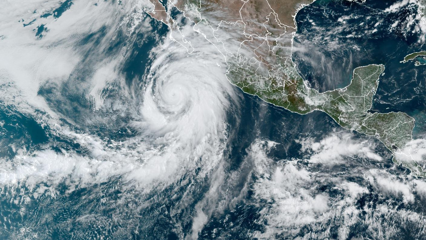
On the other side of the U.S., Hilary on Sunday became the first tropical storm to hit Southern California in 84 years before losing force as it pushed across the Southwest. Crews were mopping up the mud and clearing roads Tuesday.
Hilary first slammed ashore on Mexico's arid Baja California Peninsula as a hurricane, causing one death before becoming a tropical storm. No death, serious injuries or extensive damage was reported in California but the storm dumped record rainfall. Death Valley had it's rainiest day on record Sunday when 2.2 inches (5.6 centimeters) fell, according to John Adair, senior meteorologist at the National Weather Service in Las Vegas.
TEXAS EMERGENCY PREPAREDNESS
- For information on Texas evacuation routes, see txdot.gov/driver/weather/hurricane.html
- For information on creating emergency kits, see texasready.gov
- For state assistance in an emergency event, tdem.texas.gov/response/state-of-texas-emergency-assistance-registry
On Monday, Gov. Greg Abbott ordered the Texas Division of Emergency Management (TDEM) to deploy state emergency response resources and activate the Texas State Emergency Operations Center to Level II (Escalated Response Conditions) ahead of landfall in South Texas on Tuesday morning.
"Texas stands ready to deploy all available resources to South Texas as tropical storm conditions impact the region this week," said Abbott. "Ahead of heavy rainfall and dangerous winds expected tomorrow, I directed the Texas Division of Emergency Management to increase the readiness level of the State Operations Center to ensure the swift deployment of support and resources to affected communities. I encourage Texans to remain weather-aware and heed the guidance of state and local officials and emergency management personnel as they work together to keep communities safe."
The following resources have been deployed by TDEM:
- Texas A&M Engineering Extension Service (Texas A&M Task Force One): Swift Water Rescue Boat Squads and a Flood Water Boat Squad.
- Texas National Guard: Ground Transportation Platoons with High Profile Vehicles.
- Texas Parks and Wildlife Department: Texas Game Warden Search and Rescue Boat Teams.
- Texas Department of Public Safety: Tactical Marine Unit Boats and Rescue Swimmers, Search and Rescue Aircraft with Hoist Capability.
- The following actions have been taken and resources have been rostered for use if needed:
- Texas Department of Transportation: High-profile vehicles and personnel monitoring road conditions.
- Texas Department of State Health Services: Texas Emergency Medical Task Force Severe Weather Packages.
- Public Utility Commission of Texas: Power outage monitoring and coordination with utility providers.