

The month of July so far has featured a string of below-normal temperatures and summer thunderstorms.
As of Wednesday, Dallas-Fort Worth International Airport has received 1.30 inches of rain. The average high so far this month has been 91.5 degrees.
This weather pattern is about to change.
Next week, a strong area of high pressure will strengthen in the upper levels of the atmosphere. This will be the first heatwave of the season for the central part of the country, including the Dallas-Fort Worth area.
Get DFW local news, weather forecasts and entertainment stories to your inbox. Sign up for NBC DFW newsletters.

The warm-up begins this weekend. Highs in North Texas will be in the mid to upper 90s. By Wednesday, triple-digit heat looks likely.
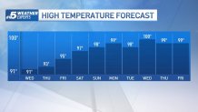
While it has been hot this year, we have yet to see triple-digit heat in North Texas. The hottest weather occurred on June 13, 14 and 17, when DFW Airport hit 99 degrees.
In an average year, DFW Airport records 20 100-degree days. The year 2011 features the most 100-degree days on record -- 71 days that summer reached 100 degrees or higher.
This heatwave is right on schedule. The end of July and the start of August is climatologically the hottest stretch of the year.

HEAT SAFETY TIPS
With heat like this, you'll want to take precautions and be prepared.
Drink plenty of fluids, stay in an air-conditioned room, stay out of the sun, and check up on relatives and neighbors to ensure they stay cool.
Young children and pets should never be left unattended in vehicles. According to the National Safety Council, if it's 95 degrees outside the internal temperature of a car could climb to 129 degrees in 30 minutes. After just 10 minutes, temperatures inside could reach 114 degrees.
A child's body temperature heats up three to five times faster than an adult and heatstroke can begin when a person's core body temperature reaches 104 degrees. A core temperature of 107 degrees is lethal, according to the Texas Department of State Health Services.
Take extra precautions if you work or spend time outside. When possible reschedule strenuous activities to early morning or evening. Know the signs and symptoms of heat exhaustion and heatstroke. Wear lightweight and loose-fitting clothing when possible. To reduce risk during outdoor work, the Occupational Safety and Health Administration recommends scheduling frequent rest breaks in shaded or air-conditioned environments. Anyone overcome by heat should be moved to a cool and shaded location. Heatstroke is an emergency! Call 911. The CDC has more here on heat-related illnesses.
Take care of your pets by providing fresh, cool water and shade. Also, pets should not be left outside and unattended for too long. It's too hot and they need to be brought inside.
