Monday, DFW Airport recorded a record high temperature for the day. The thermometer reached 94 degrees beating the previous record of 90 degrees. That is the third hottest temperature we have seen during February. On February 25, 1904, the high was 96 degrees. On February 21, 1996, the temperature reached 95 degrees.
Highs will reach the upper-70s to upper 80s Tuesday afternoon. Some areas will approach the record of 85 set back in 1918.
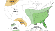
Does this early warmth mean we are in store for a hot summer? Not necessarily. The National Weather Service in Ft. Worth says "Spring rainfall is a much better predictor for summer temperatures, but the spring precipitation outlook is inconclusive." The Climate Prediction Center has the long-range rainfall forecast for North Texas as an equal chance for either being above or below normal.
Get DFW local news, weather forecasts and entertainment stories to your inbox. Sign up for NBC DFW newsletters.
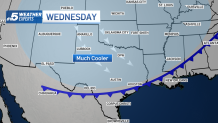
This little stretch of extreme warmth comes to an end tonight. A strong cold front moves through by daybreak Wednesday.
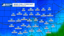
The wind chill on Wednesday morning will be in the 20s and 30s. Afternoon highs Wednesday afternoon will be in the 50s.