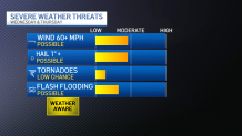
Scattered severe thunderstorms remain possible Thursday evening and could produce very large hail greater than three inches in diameter and damaging winds.
The National Weather Service issued several Severe Thunderstorm Warnings Thursday afternoon as storms moved toward the Metroplex from the west. The main threats from the storms were wind gusts to 60 mph and hail ranging in size from golf ball-sized to baseball-sized.
Hail ranging in size from quarters to baseballs falls on North Texas
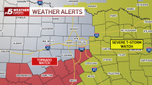
A Tornado Watch issued until 9 p.m. Thursday for 19 counties was rolled back at about 6 p.m., removing Dallas and Tarrant counties but leaving Ellis, Hill, Bosque and Hamilton. The NWS has also canceled a Severe Thunderstorm Watch for several counties to the north and along the Red River.
Get DFW local news, weather forecasts and entertainment stories to your inbox. Sign up for NBC DFW newsletters.
Two Severe Thunderstorm Watches remain in effect for counties in East Texas until 11 p.m. and midnight.
There were reports of injuries and damage from a tornado in Delta County. Check back and refresh this page for the latest information on that storm.
SEVERE WEATHER POSSIBLE THURSDAY
Severe weather is again likely in North Texas on Thursday. The Dallas-Fort Worth area is under a Level 3 risk for severe weather.
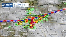
Storms Thursday will be capable of producing large hail, damaging winds, and tornadoes. Storms will develop along a stalled frontal boundary and are possible through the afternoon.
Heavy rain is also possible around the time kids get out of school and for the evening commute. Large hail and damaging winds will be the primary concerns on Thursday. While the tornado threat is low, it's not zero.
Continue to check back for further updates!

CONTINUING WEATHER COVERAGE
Stay up to date with the latest weather forecast from NBC 5's team of Weather Experts by clicking here or by watching the video below.