

A rare late-season cold snap forced many North Texas to cover and bring newly planted flowers and plants inside for the night.
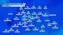
Temperatures early Wednesday morning were in the 30s.

DFW Airport has a record low temperature reading for the day. The low was 37 degrees, two degrees lower than the previous record of 39 degrees set over 100 years ago.
Get DFW local news, weather forecasts and entertainment stories to your inbox. Sign up for NBC DFW newsletters.
Several North Texas cities were in the low 30s.

Denton actually dropped below freezing with a low of 30 degrees.
Bridgeport fell into the 20s!
It will stay chilly for another day with below normal temperatures, but Friday brings a return to our typical spring weather.
Highs on Friday will be in the mid-70s. Our next big storm system also arrives on Friday.
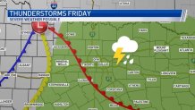
This storm system will bring a chance for widespread rain and thunderstorms. It is looking likely that storms on Friday could produce severe weather. As of now timing looks to be during the afternoon and evening hours, but there is still some uncertainty in the forecast. In the days to come we will be using the risk and timing. For now, plan on being weather aware on Friday.
