


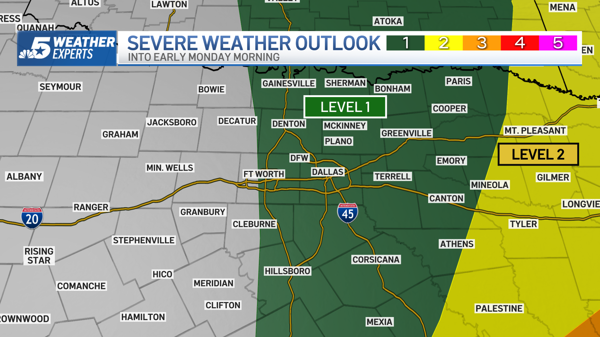
We could see additional storms fire up into early Monday morning, those also could turn severe, especially for locations in East Texas.

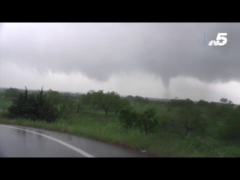
STORMS DROP RAIN AND HAIL, PROMPT TORNADO WARNINGS ON FRIDAY
Get DFW local news, weather forecasts and entertainment stories to your inbox. Sign up for NBC DFW newsletters.

A Tornado Watch remains in effect until 6 p.m. for central and north central Texas.
At 4:48 p.m., the NWS issued a Tornado Warning for central Van Zandt County until 5:15 p.m. due to a severe thunderstorm capable of producing a tornado located over Canton, moving east at 50 mph.
At 4:42 p.m., the NWS canceled the Tornado Warning for Kaufman County but continued the warning for Van Zandt County.
At 4:30 p.m., the NWS continued a Tornado Warning until 5 p.m. for southeastern Kaufman County and southwestern Van Zandt County. At 4:29 p.m., a severe thunderstorm capable of producing a tornado was located 7 miles north of Mabank, or 10 miles north of Gun Barrel City, moving east at 35 mph.
At 4:20 p.m., the NWS issued a Tornado Warning for southeastern Kaufman County and southwestern Van Zandt County until 5 p.m. after a severe thunderstorm capable of producing a tornado was located over Kemp or 9 miles northwest of Gun Barrel City, moving east at 35 mph.
At 3:49 p.m. the NWS issued a Severe Thunderstorm Warning for southeastern Hunt County, Kaufman County, Van Zandt County, northwestern Henderson County and Rains County until 4:30 p.m. due to a line of severe thunderstorms located from near Rosser to Emory, moving northeast at 35 mph.
At 3:46 p.m., the NWS issued a Flash Flood Warning for Kaufman County until 6:30 p.m. Emergency management reported flash flooding ongoing in parts of Kaufman County due to heavy rainfall. Between 2 and 3 inches of rain have fallen. The expected rainfall rate is 1 to 2 inches per hour. Additional rainfall amounts of 2 to 4 inches are possible. Flash flooding is already occurring, with many roads becoming impassable. Some high-water rescues are in progress in the town of Kaufman.

At 3:35 p.m., the Tornado Warning in Hill County was canceled. The tornado threat has diminished. However, large hail and damaging winds remain likely and a Severe Thunderstorm Warning remains in effect for the area.
At 3:15 p.m. a severe thunderstorm capable of producing a tornado was located near Aquilla Lake, or near Hillsboro, moving northeast at 40 mph.
At 3:01 p.m., the NWS issued a Tornado Warning for central Hill County until 3:45 p.m. for a severe thunderstorm capable of producing a tornado located near Lake Whitney, or 15 miles southwest of Hillsboro, moving east at 40 mph.
At 2:44 p.m., the Tornado Warnings in Kaufman, Henderson, and Ellis counties are canceled. The rotation associated with the storm that prompted the Tornado Warning has weakened and no longer appears capable of producing a tornado.
At 2:30 p.m., the NWS issued a Tornado Warning for southwestern Kaufman County, northwestern Henderson County and east-central Ellis County until 3:15 p.m. due to a severe thunderstorm capable of producing a tornado near Alma, or 9 miles east of Ennis, moving northeast at 25 mph.
At 2:11 p.m., a severe thunderstorm capable of producing a tornado was located near Alma, or 9 miles south of Ennis, moving northeast at 30 mph.
At 2:04 p.m., a confirmed tornado was located in Navarro County near Emhouse, or 9 miles northwest of Corsicana, moving northeast at 30 mph. At 2:09 p.m., the NWS said the circulation was weakening.
At 1:57 p.m., a confirmed tornado was located near Bynum, or near Hillsboro, in Hill County, moving northeast at 30 mph. Emergency management reported a tornado near Hill County Road 3106 moving toward Farm-to-Market Road 1242. This warning is expected to expire at 2:15 p.m. though gusty winds and heavy rain are still possible.
At 1:52 p.m., the National Weather Service issued a Tornado Warning for southeastern Ellis County and northwestern Navarro County until 2:30 p.m. A confirmed tornado was located near Barry, or 10 miles west of Corsicana, moving northeast at 30 mph.

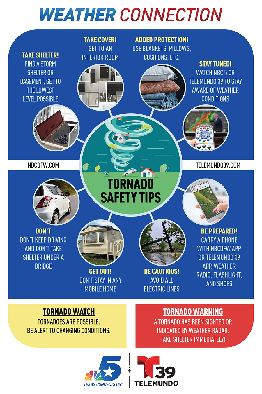
HOW TO PREPARE FOR STORM SEASON IN NORTH TEXAS


CONTINUING WEATHER COVERAGE
Stay up to date with the latest weather forecast from NBC 5's team of Weather Experts by clicking here or by watching the video below.

Be prepared for your day and week ahead. Sign up for our weather newsletter.

