A cold front will sweep across North Texas late tonight bringing a shot of cooler and drier air. Tuesday will be much cooler with a gusty northwest wind. Highs will be in the 50s and 60s. Expect dry weather and a warming trend Wednesday through Saturday with highs returning to the 70s. Rain chances increase by Sunday into early next week.
Severe thunderstorms are expected late Monday afternoon and into the evening in North Texas bringing a chance for large hail and damaging wind.
Some of the storms could vary between strong to severe as a dryline and cold front move through North Texas.
The Storm Prediction Center has placed much of North Texas under an Enhanced Risk (level 3 out of 5) for severe storms with a Moderate Risk (level 4 out of 5) for northwest North Texas. Storm timing in the Metroplex is expected to be between 4 p.m. to 10 p.m. with activity expected in Tarrant County at about 7 p.m.
The primary concerns are large hail and damaging winds (wind 60 mph+). While the tornado threat is low, it's not zero.
Megan King
Hail storm 4/1/24 – Rhome, Texas 710pm
Katie Ladner
Golf ball size hail in Argyle – harvest neighborhood
Gregory parent
Justin texas behind TMS on cactus ct.
David Fidone
Huge hail in old town Justin
parker ciccarelli
Here are pictures from some hail here in Denton/Corinth area. Behind bucees in Unicorn Lake @ 7:45pm.
Allan Family
Would love to send u video of the hail in rhome. Its 2-3 inches
Calum Allan
Christa Christian
3 rounds of hail getting progressively larger between 6:30 and 6:45pm.
Jenifer Mahan
Paradise Tx Jenifrr Mahan 6:35 pm
Jeremy
Hail in Rhome
Allan Family
Would love to send u video of the hail in rhome. Its 2-3 inches
Calum Allan
Allan Family
Would love to send u video of the hail in rhome. Its 2-3 inches
Calum Allan
Lexis Delgado
Lexis estrada in Boyd tx
Megan Poppel
Late hail in city of Rhome Wise county
Beth Woods
Rhome Hail storm 4/1/2024
ernestmorales744
Boyd Texas
ernestmorales744
Boyd Texas
ernestmorales744
Boyd Texas
Lori Kooiman
Hail in Northlake/Argyle. Hen-size hail
Mandi Pitzer
We are getting a lot of hail in Argyle, TX and wanted to share. I hope everyone is okay!
Jason Fenn
Argyle hail—7:31pm on April 1
Darla Smith
Northlake TX weather 4.1.24
Blessings,
Darla J. Smith
“The Lord bless you and keep you; the Lord make his face to shine upon you and be gracious to you; the Lord lift up his countenance upon you and give you peace.”
Rob Garfat
Here is a picture of Hale from South Denton near the Argyle line
Lisa Pulver
Hail Storm Justin Texas, April 1 2024
Jason Fenn
Just west of 407 and I35w. 7:33pm
Jason Fenn
Just west of 407 and I35w. 7:33pm
Tommy Noel
Hail in Argyle around 7:30 pm Monday
Tommy Noel
Hail in Argyle around 7:30 pm Monday
Tommy Noel
Hail in Argyle around 7:30 pm Monday
Tommy Noel
Hail in Argyle around 7:30 pm Monday
Megan Poppel
Here are some pics of the hail we just received in Rhome.
Megan Poppel
Here are some pics of the hail we just received in Rhome.
Megan Poppel
Here are some pics of the hail we just received in Rhome.
Megan Poppel
Here are some pics of the hail we just received in Rhome.
Megan Poppel
Here are some pics of the hail we just received in Rhome.
Megan Poppel
Here are some pics of the hail we just received in Rhome.
Kathy Gissler
We had a lot of hail this size in Argyle between 35W and 377 off of Crawford Road.
curtis nail
Hail in Rhome texas
Sent from Yahoo Mail for iPhone
Kimberly Verhoev
These pictures of from hail in Justin Tx. We are in the unincorporated area.
Kimberly Verhoev
These pictures of from hail in Justin Tx. We are in the unincorporated area.
olivia wettstein
Hail in Northlake Tx at 7:30 pm on April 1
Amy Stephens
Found this in my front yard after the hail came through Justin, TX
Emily Porter
Didn’t get a lot of it but what we got was large!
Thanks for the coverage,
Emily Porter
Robin Bahlman
Hail in Pecan Plantation, between Granbury and Glen Rose.
curtis nail
Hail in Rhome texas
Sent from Yahoo Mail for iPhone
Tom Neagli
9709 Salford Way Robson Ranch Denton
Cole Dodson
Argyle hail, just West of 35W
curtis nail
Hail in Rhome texas
Sent from Yahoo Mail for iPhone
Michael Coté
Hail storm… Granbury, Texas tonight at 7:15 pm on April 1, 2024
Kathy Derr
Newark, TX. When the storm passed thru about 20 min ago.
olivia wettstein
Hail in Northlake TX on April 1
Jeff Berger
Hail in Pecan Square in Northlake Texas
Michael Cote
These are some hail stones that just fell here at our home in Granbury,
Texas tonight at 7:15 pm on 4/1/24.
DeeDee Gage
Neighbors pergula roof blew in from two houses away…
Share your photos and videos with NBC 5 by emailing iSee@nbcdfw.com
As the storms built west of the Metroplex and moved east, the National Weather Service warned of very large hail up to baseball-sized and wind gusts above 85 mph. Hail of that size could injure people and animals outdoors and damage roofs, siding, windows and vehicles.
Make sure you stay "weather aware" on Monday afternoon and evening and continue to check back for additional updates.
WATCHES AND WARNINGS
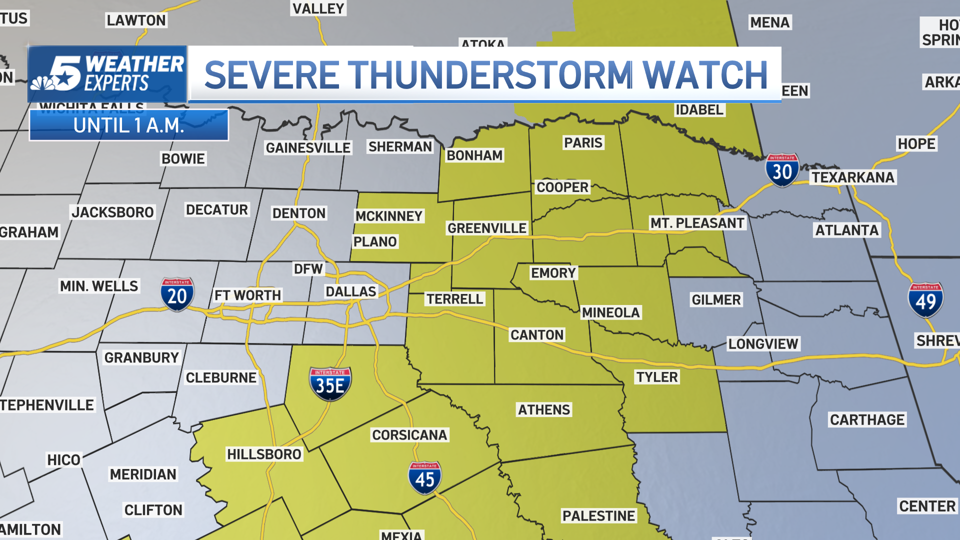
A new Severe Thunderstorm Watch has been issued until 1 a.m. for areas east of DFW into East Texas.
The National Weather Service has updated the severe weather outlook. NBC 5 Meteorologist Kevan Smith says stay weather aware, severe storms expected late Monday afternoon and evening.