What to Know
- Rain developed after sunrise, sleet-snow mix developed by mid-morning.
- Bridges and overpasses may become slick.
- Accumulation is possible across Dallas-Fort Worth, especially farther north.
Another shot of winter arrived early Friday morning in North Texas, bringing a cold front, a strong north wind and a wintry mix of sleet, snow and rain.
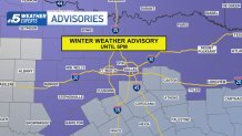
A Winter Weather Advisory across North Texas was expanded overnight to include Fort Worth and Dallas.
Light rain began to move into North Texas shortly after sunrise. This rain will transition into sleet and snow.
Get DFW local news, weather forecasts and entertainment stories to your inbox. Sign up for NBC DFW newsletters.
Locations in the advisory have the highest potential for having some slick spots, especially on bridges and overpasses.
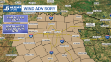
In addition, a Wind Advisory is in effect for Friday for the potential for northerly winds gusting up to 45 mph.
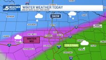
An Arctic cold front pushed sharply colder air into North Texas early Friday. As temperatures fell into the low to mid-30s, rain mixed with sleet and could also bring snow to some areas. In addition, the wind will be very strong from the northwest.
Problems will likely be more significant on the northern sides of the Metroplex. Accumulation of 1/2" is possible in DFW with higher totals possible farther north. Accumulation of one to two inches is possible to the north/northeast with the potential for a brief burst of heavy snow.
That said, some slushy accumulation even on the main roads is possible.
Some slick travel is possible, especially on exposed, elevated surfaces such as bridges.
The winter mix will taper off by late afternoon. The sky will eventually clear out this evening as the temperature drops into the mid-20s tonight.
Saturday morning temperatures will be in the low to mid-20s. The day will be sunny with afternoon temperatures in the 50s. Expect a bigger warmup Sunday into next week.