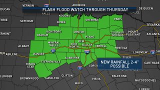
A Flash Flood Watch is extended through Thursday as a line of thunderstorms moves across North Texas Wednesday morning. Some storms may contain gusty winds and small hail, but the overall intensity of the storms will diminish through the morning.
The most likely time for storms will be from 3-6 a.m. in Dallas-Fort Worth. After that, rain chances diminish considerably.
Several Flash Flood Warnings were issued in the area.
There have been several crashes reported in North Texas Wednesday morning.
Many lanes are closed at southbound Interstate 35W and Ripy Street and some drivers are getting by. Traffic is backed up to Berry Street.
Reports of Road Flooding
The heavy overnight rain led to flooded roads and traffic problems for the Wednesday morning commute.
In Dallas, high water was reported in the following areas:
- Audelia Road and LBJ Freeway
- Harry Hines Boulevard and Walnut Hill Lane
- North Stemmons Freeway and Walnut Hill Lane
- Northwest Highway and Technology Boulevard
In Irving, high water closed several lanes of westbound Texas 183 at Valley View Lane. High water was also reported along eastbound Texas 114 and Northwest Highway.
Prosper police warned of several roads being closed due to floodwaters.
The biggest risk with the storms will be heavy rain. A Flash Flood Watch is in effect for much of North Texas, including the Dallas-Fort Worth area, through Thursday evening. Rain amounts overnight could be 1-2 inches, leading to areas of flooding.
Additional rounds of storms are likely Wednesday evening into Thursday.
Weather Connection
Connecting you with your forecast and all the things that make North Texas weather unique.