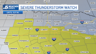
A Severe Thunderstorm Watch has been issued for parts of North Texas. The most likely timeframe will be from mid-afternoon into the evening.
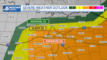
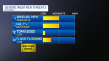
The Storm Prediction Center has placed central and southern North Texas in an enhanced (level 3) risk into this evening. Large hail and damaging wind gusts will be the main threats, but a low tornado threat will exist as well.
Get DFW local news, weather forecasts and entertainment stories to your inbox. Sign up for NBC DFW newsletters.
We have had several thunderstorms over the past few days with little in the way of any severe storms. This will change into this evening as winds in the mid-atmosphere will be increasing. Those stronger jet stream winds can lead to increased wind shear which will help develop more organized severe storms. We tend to see stronger wind shear more in the early to mid-spring, but it can still occur out through mid-June.
Stronger storms are expected this afternoon and evening. While the exact timing is still in question, this is how one computer model suggests the radar will look like Saturday afternoon into the evening:
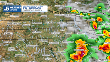
The storms will move into East Texas Saturday evening, and eventually into Louisiana later Saturday night.
Again, not everyone will get a storm. However, given the fact that any storms could produce strong winds, hail and lightning, it will be a good idea to stay weather aware on Saturday.