
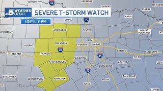
The National Weather Service issued a Severe Thunderstorm Watch at 1:32 p.m. for 13 counties including Comanche, Eastland, Erath, Hamilton, Hood, Jack, Mills, Palo Pinto, Parker, Somervell, Stephens, Wise and Young counties until 9 p.m.
Primary threats include scattered large hail and isolated very large hail events to 2.5 inches in diameter are likely. Scattered damaging wind gusts to 70 mph are likely.
The NWS says "Thunderstorm development is underway south of Abilene, in an environment that favors continued expansion and intensification of the storms through the afternoon. A mix of multicell clusters and some supercell structures will be possible, with an attendant threat for large hail up to tennis ball size, and damaging outflow gusts up to 70 mph. The severe thunderstorm watch area is approximately along and 55 statute miles east and west of a line from 45 miles north northwest of Mineral Wells TX to 75 miles south-southwest of Brownwood TX."
Storms are not expected in the Interstate 35 corridor until around 4 p.m.
Get DFW local news, weather forecasts and entertainment stories to your inbox. Sign up for NBC DFW newsletters.
If you haven't already, download our app now so that you'll receive timely storm alerts and notifications (phones/tablets) of live weather updates as the next round of storms move into the Metroplex. Click here to get the NBC 5 app for your phone, tablet, or television.
