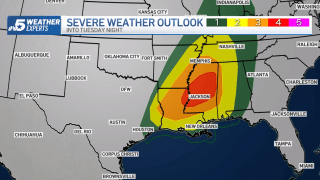
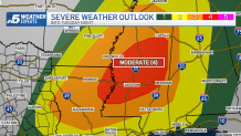
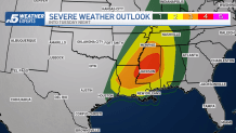
A powerful storm system will sweep across the Central Plains Tuesday and into the Deep South. As moisture-rich air is pulled up from the Gulf of Mexico, the ingredients for thunderstorms will come together.
These storms will initially develop across Louisiana and eastern Arkansas by late afternoon. The storms will intensify and likely become severe toward evening time. A cold front will drive the storms eastward and across the Mississippi Valley overnight.
Some of these storms will be capable of rotating updrafts with the possibility of large, long-track tornadoes and the area of greatest concern for tornadoes is in northeastern Louisiana and central Mississippi.
Get DFW local news, weather forecasts and entertainment stories to your inbox. Sign up for NBC DFW newsletters.
The Storm Prediction Center has the area outlined in a "Moderate" risk category. This category is rare during spring storm season and exceptionally rare for this time of year.
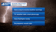
What makes this situation especially concerning is that these tornadoes are possible during overnight hours. Not only will it be dark, making the tornadoes difficult for spotters to see, but they could strike at a time when most people are sleeping.
Weather Connection
Connecting you with your forecast and all the things that make North Texas weather unique.


If you have friends and family in this region, make sure they are aware of the severe weather potential later today and especially tonight. Encourage them to follow their local media closely as the event unfolds.
These storms will not affect North Texas, but it's always good to review your plan in the event of nighttime severe weather.