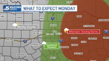
A storm system expected to sweep through North and East Texas Monday may bring a chance of rain along with the potential for severe weather.
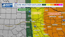
The western half of the DFW Metroplex has a marginal risk for severe weather while the eastern half is under a slight risk. Most of the area is likely to see only scattered showers.
East Texas is under an enhanced risk, where there is a more significant concern for dangerous weather. The severe weather threat will increase the farther east you go.
Get DFW local news, weather forecasts and entertainment stories to your inbox. Sign up for NBC DFW newsletters.
The National Weather Service said Monday afternoon that the cap weakened throughout the morning and that storms were expected to intensify across East Texas throughout the afternoon.
At about 3:30 p.m., the NWS said initial attempts at storm development were struggling but that storms could still be possible east of Interstate 35 and along/north of Interstate 20.
High winds, hail and even a few tornadoes are possible in areas where severe storms are expected.
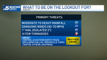
Stay weather aware and have multiple ways to receive severe weather warnings.
Get DFW local news, weather forecasts and entertainment stories to your inbox. Sign up for NBC DFW newsletters.