
Rounds of showers and thunderstorms have brought flooding and high winds to North Texas. Meanwhile, the extensive cloud cover and rain have also brought a refreshing drop in temperatures.
Over the past weekend, Dallas-Fort Worth International Airport recorded a record high Saturday of 106 degrees. Four days later the high temperatures will reach the low 80s.
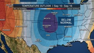
The normal high temperature for the start of September is 93 degrees. For the rest of the week, highs will be below-normal. This cooler-than-normal trend looks to continue. The Climate Prediction Center’s long-range forecast calls for North Texas to see below-normal temperatures. This forecast is valid through Sept. 16.

Next week could really feel like fall in North Texas as our first fall-like cold front is forecast to sweep through mid-week.
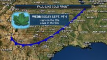
A cold front next Wednesday will bring additional rain chances and some of the coolest weather we have seen in a while. Highs next Wednesday will be in the upper 70s and lows in the 50s.
Local
The latest news from around North Texas.


The forecast could change, but as of now, it looks like we are in store for some refreshingly cooler air next week.
