
S Band Radar & Maps | Forecast | Weather Alerts
Traffic | Send Us a Photo/Video | Live Cams
A storm system will move into Texas late Friday night into Saturday morning with unsettled weather. There will several rounds of showers and thunderstorms, but not continuous most of the weekend.
Warm and humid air will be in place Friday afternoon, resulting in an unstable atmosphere by Friday evening. As the first of several impulses approaches the region Friday night, isolated to scattered storms will increase from west to east. Several rounds of storms late Friday night into Saturday evening will bring a threat for locally heavy rain and minor flooding, especially for areas east and south of Dallas-Fort Worth.
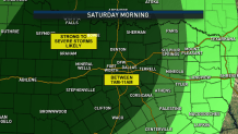
The stronger storms could produce large hail or high winds. Prepare now if you have outdoor activities planned early this weekend and be sure to stay weather aware.
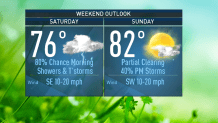
There is still a slight chance for storms Sunday, but as a cold front moves through Sunday night, that chance disappears.
Weekend Forecast
Saturday- 80 percent chance for storms. Mostly cloudy and windy. High: 76.
Sunday- 40 percent chance for storms. Mostly cloudy, slight breeze. High: 82.
The latest video forecast from NBC DFW team of Weather Experts will appear in the player above. Keep up with the latest changes to the weather by downloading the NBC DFW smartphone App for iOS and Android!
Get the latest forecast information from NBC 5's team of Weather Experts here.
 Interactive Radar |  NBC 5 S-Band |  Dallas County |  Tarrant County |
 Collin County |  Denton County |  Ellis, Johnson Co. |  Rainfall Totals |
