
S Band Radar & Maps | Forecast | Weather Alerts
Traffic | Send Us a Photo/Video | Live Cams
Winds of 60 to 70 mph in DFW resulted in power outages and knocked down some trees. The storms are moving to the south early Monday morning.
A few showers have redeveloped towards Stephenville and Ranger.
Later in the day Monday, there could be spotty thunderstorms for North Texas with a 20 to 30 percent chance.
 Interactive Radar |  NBC 5 S-Band |  Dallas County |  Tarrant County |
 Collin County |  Denton County |  Ellis, Johnson Co. |  Rainfall Totals |
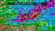
A cold front brought widespread thunderstorms into North Texas Sunday night producing lightning, brief heavy rain, and the potential for gusty winds.
After the storms moved through, the threat for severe weather diminished and rain-cooled air remained.
Heavy rain may lead to flash flooding as well. Rainfall totals through Monday morning could range from 1 to 3 inches.
Local
The latest news from around North Texas.


The latest video forecast from NBC DFW's team of Weather Experts will appear in the player above. Keep up with the latest changes to the weather by downloading the NBC DFW smartphone App for iOS and Android!
Read the latest forecast information from NBC 5's team of Weather Experts here.
- Stay Connected. Download the NBC DFW App
- Set your push alert preferences.
- Charge your phones and tablets so that if you lose power you can still watch live weather coverage in the App.
| Stay Safe During a Hail Storm At Home?
Outdoors?
Driving?
|
