S Band Radar & Maps | Forecast | Weather Alerts
Traffic | Send Us a Photo/Video | Live Cams
 Interactive Radar |  NBC 5 S-Band |  Dallas County |  Tarrant County |
 Collin County |  Denton County |  Ellis, Johnson Co. |  Rainfall Totals |
Live video from the NBC 5 Weather Center will appear in the player above.
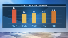
Hang in there! Heat relief is on the way. A rare July cold front is moving into North Texas and bringing with it some summer thunderstorms.
Initially, this front won't dramatically drop the temperature. In fact, today will still be quite hot (mid 90s). However, the wind will shift to the north today, ushering in lower humidity and a gradual cool-down by this evening.
Along, and behind, the front, there could be a few stray showers or storms. Some heavy downpours and gusty winds are possible, but there's no concern for severe weather.

Not only will we have high temperatures dropping into the upper 80s to around 90 degrees for a few days, we will also have some comfortable mornings to enjoy. In fact, the low temperatures Wednesday, Thursday, and Friday will get down close to record low temperatures! It's unlikely we will set any record lows, but it will sure feel nice those mornings.

By the way, so far this year we have not had a 100-degree day at DFW Airport. That's quite a feat, especially since we're more than three weeks into the month of July. In case you're wondering, the last time we had zero 100-degree days in July was back in 2007!
We will slowly start to warm back up as we go through the second half of this week and into the weekend. By next weekend, we will also notice the humidity levels going back up. My best advice is to enjoy the break in the heat and humidity as much as you can.