
S Band Radar & Maps | Forecast | Weather Alerts
Traffic | Send Us a Photo/Video | Live Cams
Our damp, showery weather pattern will continue through Saturday morning.
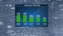
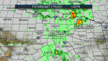
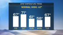
Friday will be cloudy with scattered showers across North Texas. A couple of thunderstorms are possible, too, as a warm front moves north through the area. Temperatures will rise from the 40s to the upper 60s Friday.
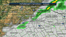
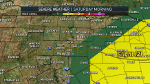
The rain chances will decrease after a line of showers and storms moves east across the region Saturday morning.
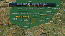
Isolated severe storms will be possible across North Texas early Saturday morning. The threat for severe storms will shift to the east as a cold front moves through. Main threats will be large hail and damaging winds. An isolated tornado cannot be ruled out.
Temperatures will be mild Saturday, but cool back into the 50s and 60s for Sunday and Monday. The weather next week looks rather quiet.
Local
The latest news from around North Texas.


The latest video forecast from NBC DFW's team of Weather Experts will appear in the player above. Keep up with the latest changes to the weather by downloading the NBC DFW smartphone App for iOS and Android!
Read the latest forecast information from NBC 5's team of Weather Experts here.
- Stay Connected. Download the NBC DFW App
- Set your push alert preferences.
- Charge your phones and tablets so that if you lose power you can still watch live weather coverage in the App.
| Stay Safe During a Hail Storm At Home?
Outdoors?
Driving?
|
 Interactive Radar |  NBC 5 S-Band |  Dallas County |  Tarrant County |
 Collin County |  Denton County |  Ellis, Johnson Co. |  Rainfall Totals |
