
S Band Radar & Maps | Forecast | Weather Alerts
Traffic | Send Us a Photo/Video | Live Cams
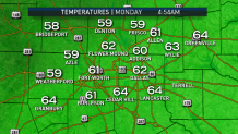
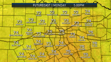
A cold front has ushered in the coolest temperatures of the season. North Texans are starting their Monday morning in the low 60s and upper 50s.
This is a huge drop from the record high reading DFW Airport recorded Sunday. 97 degrees was the afternoon high yesterday. The first six days of October the high reached 90 degrees or higher.
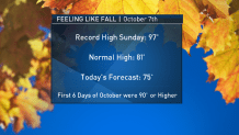
The normal high for this time of year is 81 degrees. The high today will be 75 degrees with a northeast wind around 20 mph.
This taste of fall will be brief. A warm up is expected Wednesday and Thursday. Highs will approach 90 degrees.
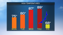
A strong cold front will bring another drop in temperatures by Friday and into the upcoming weekend. A few strong thunderstorms will also be possible.
Local
The latest news from around North Texas.


The latest video forecast from NBC DFW's team of Weather Experts will appear in the player above. Keep up with the latest changes to the weather by downloading the NBC DFW smartphone App for iOS and Android!
Read the latest forecast information from NBC 5's team of Weather Experts here.
- Stay Connected. Download the NBC DFW App
- Set your push alert preferences.
- Charge your phones and tablets so that if you lose power you can still watch live weather coverage in the App.
| Stay Safe During a Hail Storm At Home?
Outdoors?
Driving?
|
 Interactive Radar |  NBC 5 S-Band |  Dallas County |  Tarrant County |
 Collin County |  Denton County |  Ellis, Johnson Co. |  Rainfall Totals |
