
Friday marks the first day of March, but try telling that to Mother Nature. Winter won't be leaving without a fight, as the cold air that's already in place will be reinforced, and then reinforced some more!
The current forecast has highs in the 30s and 40s by Sunday into early next week with lows in the 20s.
S Band Radar & Maps | Forecast | Weather Alerts
Traffic | Send Us a Photo/Video | Live Cams
The next seven days will be the coldest start to March since 2015. The average temperature from March 1 - 7 will be 41.1 degrees (highs and lows combined, based on the 10 Day Forecast below). This will make it the coldest stretch in four years, a period during which the normal temperature is 54.4 degrees.
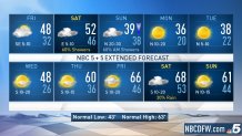
March 1 - 7 (high and low temps averaged)
2019: 41.1
2018: 58.6
2017: 60.4
2016: 61.4
2015: 38.2
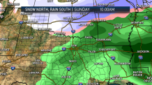
As for any snow chances, right now it looks more like a cold rain over the weekend. If there's any chance of snow it will be Sunday. Although right now it's looking like the better chance will stay to our north. It certainly bears watching, so stay tuned.
Get the latest forecast information from NBC 5's team of Weather Experts here.
Weather Connection
Connecting you with your forecast and all the things that make North Texas weather unique.


 Interactive Radar |  NBC 5 S-Band |  Dallas County |  Tarrant County |
 Collin County |  Denton County |  Ellis, Johnson Co. |  Rainfall Totals |
