
S Band Radar & Maps | Forecast | Weather Alerts
Traffic | Send Us a Photo/Video | Live Cams
Rain and storms moved through North Texas Saturday. Most of the storms did not reach severe limits, but they produced small hail and winds around 30-40 mph. Very heavy rain and lightning also accompanied storms.
A tornado watch for counties south and east of Dallas ended at 6 p.m. The watch included the counties of Anderson, Ellis, Freeston, Henderson, Hill, Kaufman, Navarro, Rains and Van Zandt. Be sure you and your family have a weather safety plan.
Make sure you stay weather aware through the day. Take time to download the free NBCDFW app so that you can watch streaming live weather coverage from the NBC 5 Weather Experts.
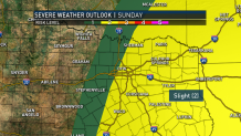
Additional storms are possible on Sunday from near DFW to the east. There will once again be a threat for a few severe storms. Large hail and 60 mph+ winds will be the main threats but we can't rule out the possibility of a tornado.
Get the latest forecast information from NBC 5's team of Weather Experts here.
Local
The latest news from around North Texas.


 Interactive Radar |  NBC 5 S-Band |  Dallas County |  Tarrant County |
 Collin County |  Denton County |  Ellis, Johnson Co. |  Rainfall Totals |
The latest video forecast from NBC DFW team of Weather Experts will appear in the player above. Keep up with the latest changes to the weather by downloading the NBC DFW smartphone App for iOS and Android!
