
S Band Radar & Maps | Forecast | Weather Alerts
Traffic | Send Us a Photo/Video | Live Cams
It continues to look like rain, but where is it? In fact, the past several days have looked like the sky could open up at any moment. So why haven’t we seen much rain even though the clouds and humidity are in place? Well, the reason is because not all the ingredients are in place yet to produce storms.
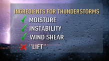
There are four main ingredients for thunderstorms to occur.
1. Moisture: CHECK.
We obviously have moisture in place with all the cloud cover and high humidity.
2. Instability: CHECK.
This refers to a combination of heat and humidity. Instability is highest when colder air resides above a layer of warm air.
Local
The latest news from around North Texas.


3. Wind Shear: CHECK.
This is when the wind direction or speed changes with height. For example, today we have a strong south wind on ground level. Higher up though, the wind is even stronger and out of the west.
4. Lift: ABSENT!
We can have all three of the above ingredients, but if there’s no “lift,” storms won’t develop. A lifting mechanism can be a cold front, dry line, etc. It can also simply be air that is rotating upward. We call this “vorticity.” Vorticity is generated by low pressure systems spinning in the upper atmosphere. Lift over the next few days will be a combination of vorticity, a dry line, and a cold front. Thus, rain and storm chances will be quite high Thursday and Friday as the missing ingredient comes into place.
Get the latest forecast information from NBC 5's team of Weather Experts here.
 Interactive Radar |  NBC 5 S-Band |  Dallas County |  Tarrant County |
 Collin County |  Denton County |  Ellis, Johnson Co. |  Rainfall Totals |
