
S Band Radar & Maps | Forecast | Weather Alerts
Traffic | Send Us a Photo/Video | Live Cams
Get ready to sweat North Texas! Temperatures and humidity will be on the rise and the heat index will be dangerously hot Wednesday afternoon. Heat index values could range from 105 to nearly 111 degrees across the area.
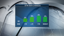
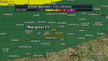
Although most of Wednesday will be dry, showers and thunderstorms will fire up in the evening as a cold front slides south into the area. Widespread severe weather is not expected, but damaging winds and frequent lightning will be the main threats.
Temperatures will cool by a few degrees on Thursday, but not much relief from the heat is expected with highs in the mid 90s and feels like temperatures between 100 and 105 degrees.
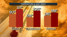
Make sure you're slowing your level of activity if working or spending time outdoors next few days. Take plenty of breaks, drink lots of water, wear light, loose fitted clothing and try to spend as much time out of the heat as you can. Slightly lower humidity is expected by Friday.
Local
The latest news from around North Texas.


The latest video forecast from NBC DFW's team of Weather Experts will appear in the player above. Keep up with the latest changes to the weather by downloading the NBC DFW smartphone App for iOS and Android!
Read the latest forecast information from NBC 5's team of Weather Experts here.
- Stay Connected. Download the NBC DFW App
- Set your push alert preferences.
- Charge your phones and tablets so that if you lose power you can still watch live weather coverage in the App.
| Stay Safe During a Hail Storm At Home?
Outdoors?
Driving?
|
 Interactive Radar |  NBC 5 S-Band |  Dallas County |  Tarrant County |
 Collin County |  Denton County |  Ellis, Johnson Co. |  Rainfall Totals |
