The weekend forecast continues to feature some uncertainties regarding rain chances and just exactly how warm — or cold — it's going to be across North Texas.
We are carefully watching a cold front that will stall, providing a sharp dividing line in temperatures. Where exactly this front stalls out is the uncertain part. Right now, the computer models are keeping it just north and northwest of DFW, which means the Metroplex and areas south will stay mild Friday and Saturday.
Areas to the northwest will be much colder, though. One of the computer models (image above) shows the sharp dividing line. Notice how close it is to DFW.
If this front pushes farther south, DFW will end up in the cold air too. At this time, we'll hold the high in the 60s Friday with 40s and 50s to the northwest.
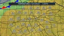
As for Saturday, there's a bit more confidence in the cold air retreating farther north. This will result in highs in the 60s and low 70s for most.
As always though, stay tuned, as this front will be a bit tricky to forecast with precision until about 24 hours out.
Farther north, there could be a significant ice event for northern Oklahoma, Kansas and parts of Missouri. Some of this may build into the panhandle, as well. Traveling to the north could be quite hazardous if this plays out late Friday and Saturday. Here's one of the models showing icy conditions Friday into Saturday (pink shading).

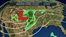
As for rain chances in North Texas, there may be a few brief, scattered showers Friday or Saturday, but the best chance of rain appears to be late Sunday when the upper low draws near. Widespread showers and thunderstorms (90 percent chance) are expected Sunday evening into Sunday night.
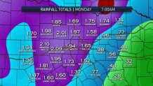
Rain totals Sunday night into Monday morning may be close to two inches!