
S Band Radar & Maps | Forecast | Weather Alerts
Traffic | Send Us a Photo/Video | Live Cams
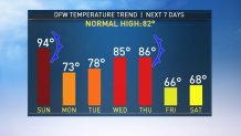
We've waited and waited... and our time has finally come. The extended summer heat is beginning to move out of North Texas and cooler air is already starting to arrive.
The first cold front moved through North Texas Sunday evening. We had quite a few showers and storms late Sunday afternoon, but many of them diminished as the sun set.
While a couple of showers will still be possible through Monday morning, the bulk of the rain will be gone by the time the sun rises Monday.
We're not done with just one cold front. We get to watch temperatures tumble a second time later this week.
Another stout front will move across North Texas late in the day Thursday. Additional storms will be possible with the second front too. The second blast of cool air will send temperatures down into the 60s for highs by Friday and lows into the 40s by Saturday morning! If you've got plans to go to the Red River Showdown on Saturday, plan on a cool and sunny day with temperatures in the 40s in the morning and in the middle to upper 60s by Saturday afternoon.
Local
The latest news from around North Texas.


The latest video forecast from NBC DFW's team of Weather Experts will appear in the player above. Keep up with the latest changes to the weather by downloading the NBC DFW smartphone App for iOS and Android!
Read the latest forecast information from NBC 5's team of Weather Experts here.
- Stay Connected. Download the NBC DFW App
- Set your push alert preferences.
- Charge your phones and tablets so that if you lose power you can still watch live weather coverage in the App.
| Stay Safe During a Hail Storm At Home?
Outdoors?
Driving?
|
 Interactive Radar |  NBC 5 S-Band |  Dallas County |  Tarrant County |
 Collin County |  Denton County |  Ellis, Johnson Co. |  Rainfall Totals |
