
S Band Radar & Maps | Forecast | Weather Alerts
Traffic | Send Us a Photo/Video | Live Cams
A strong cold front is bringing widespread rain and thunderstorms to the Dallas-Fort Worth area Thursday morning, making for a wet commute to work.
Stay aware of the potential for high water on some roads this morning. So, head out early and take it slow.
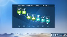
The front will move into Dallas-Fort Worth by sunrise. Temperatures will quickly fall from the 60s to the 40s and north winds will gust to near 30 mph, making it feel even colder.
The coverage of the rain will diminish during the afternoon as the front moves into Central Texas.
| Stay Safe During a Hail Storm At Home?
Outdoors?
Driving?
|
Friday will be dry and chilly with morning clouds followed by sunshine.
The weekend will be dry and milder with highs in the 60s. Another strong cold front is on tap for Veterans Day.
The latest video forecast from NBC DFW's team of Weather Experts will appear in the player above. Keep up with the latest changes to the weather by downloading the NBC DFW smartphone App for iOS and Android!
Local
The latest news from around North Texas.


Read the latest forecast information from NBC 5's team of Weather Experts here.
- Stay Connected. Download the NBC DFW App
- Set your push alert preferences.
- Charge your phones and tablets so that if you lose power you can still watch live weather coverage in the App.
 Interactive Radar |  NBC 5 S-Band |  Dallas County |  Tarrant County |
 Collin County |  Denton County |  Ellis, Johnson Co. |  Rainfall Totals |
