
S Band Radar & Maps | Forecast | Weather Alerts
Traffic | Send Us a Photo/Video | Live Cams
A strong cold front moved across North Texas early Sunday morning bringing a reinforcing shot of unseasonably cold air and a strong north wind. The rest of Sunday will be windy and very cold.
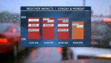
A sustained north wind between 20 to 30 mph will be common. Some wind gusts may be up around 35 mph. Wind chills will be in the teens and 20s by Sunday afternoon.
**MAKE SURE YOU TAKE COLD-WEATHER PRECAUTIONS SUNDAY NIGHT AND MONDAY MORNING. PROTECT YOUR PIPES IN YOUR HOUSE AND MAKE SURE BOTH PEOPLE AND PETS HAVE THE ABILITY TO KEEP WARM**
By Monday morning, the temperature will be close to a record low. The record is 20 degrees set back in 2002. Even if the temperature doesn't get to the record, it's going to feel much colder. Wind chill values will be down in the single digits to around 10 degrees for a large part of North Texas. Please make sure the kids are bundled up properly before stepping out the door for school Monday morning.
There is a light at the end of the tunnel, however. Temperatures will warm back up in to the 60s by Thursday and 70s for Friday and Saturday. [[414095503,C]]
Local
The latest news from around North Texas.

Get the latest forecast information from NBC 5's team of Weather Experts here.
 Interactive Radar |  NBC 5 S-Band |  Dallas County |  Tarrant County |
 Collin County |  Denton County |  Ellis, Johnson Co. |  Rainfall Totals |
