
S Band Radar & Maps | Forecast | Weather Alerts
Traffic | Send Us a Photo/Video | Live Cams
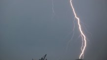
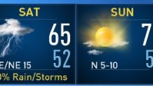
Let’s start with the bad news…it’s going to be a soggy Saturday. Yep, the timing is terrible. Expect several hours of rain Saturday afternoon. Ballgames will be rained-out and running errands will be a hassle on the wet roads. The good news, however, is that we could always use the rain this time of year and more importantly, the threat for severe weather looks low.
As Rick Mitchell pointed out recently, it’s been a slow start to severe weather season in North Texas. This weekend’s storm system will likely not have the necessary ingredients for severe weather either. Instead, it will deliver beneficial rain to all of North Texas.
While thunder and lightning will be probable here in North Texas, the severe risk will be farther south toward Waco, Austin, San Antonio and Houston. Those locations will have the risk of stronger storms that could produce some hail and gusty winds.
Here in DFW, we’ll be closely monitoring the progress of a warm front to the south. If it lifts farther north than expected, storms could be a little stronger here. For now, this is the expected setup for Saturday:
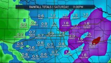
By far, this will be the most rain we’ve seen in the month of April. Preliminary estimates are close to an inch for DFW, with higher totals to the north and east.
And finally, it will not be a wash-out the entire weekend. Sunday looks nice!
Get the latest forecast information from NBC 5's team of Weather Experts here.
Local
The latest news from around North Texas.

 Interactive Radar |  NBC 5 S-Band |  Dallas County |  Tarrant County |
 Collin County |  Denton County |  Ellis, Johnson Co. |  Rainfall Totals |
