
 Interactive Radar |  NBC 5 S-Band |  Dallas County |  Tarrant County |
 Collin County |  Denton County |  Ellis, Johnson Co. |  Rainfall Totals |
S Band Radar & Maps | Forecast | Weather Alerts
Traffic | Send Us a Photo/Video | Live Cams
Today's risk of severe weather features a "high risk" category up toward Wichita Falls, Childress and much of Oklahoma.
This is the first high risk since 2017. In this area, long-track, violent tornadoes are possible.
If that wasn't bad enough, there's also likely to be gridlock on many of the rural roads due to all the storm chasers wanting to take a look.
Believe it or not, the temptation for many weather enthusiasts and photographers is to go storm chasing right into the heart of this area. In fact, this type of setup is liable to bring out several hundred chase vehicles — professional and amateur — to the highlighted area. In the chase community, it's referred to as "chaser convergence."
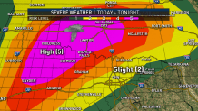
What makes chaser convergence particularly dangerous on a day like today is because the "target area" is relatively small and compact. This means everyone converges on the same spot, essentially
Local
The latest news from around North Texas.
You get inexperienced chasers into the mix that don't know what they're doing. They try to get up close and personal to tornadoes, which is flat-out stupid.
On a day like today, even for trained professionals, storm chasing is dangerous. The threat for tornadoes, combined with wet roads and a risk of flooding, gets even more dicey when roads are restricted with all the extra chase traffic.
While I certainly understand and admire the love for weather photography, today is not the day to head out for an amateur. Even for the professionals, it poses a serious threat.
Congestion on the roads in the middle of a tornado warning is a scary, dangerous thing. In this case, it's 100% preventable. If you're a weather enthusiast, there are better opportunities to go chasing. For example, when the target zone is more spread out geographically and not a high risk.
So, leave today to the professionals and official National Weather Service spotters. They are doing it to keep the public safe. They have studied these storms and know to respect them at a safe distance. After all, no picture or video is worth your life.
The latest video forecast from NBC DFW's team of Weather Experts will appear in the player above. Keep up with the latest changes to the weather by downloading the NBC DFW smartphone App for iOS and Android!
Read the latest forecast information from NBC 5's team of Weather Experts here.
- Stay Connected. Download the NBC DFW App
- Set your push alert preferences.
- Charge your phones and tablets so that if you lose power you can still watch live weather coverage in the App.
| Stay Safe During a Hail Storm At Home?
Outdoors?
Driving?
|
