
S Band Radar & Maps | Forecast | Weather Alerts
Traffic | Send Us a Photo/Video | Live Cams
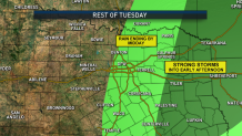
Scattered showers and thunderstorms that pushed through the Metroplex Tuesday morning have moved east.
A few stronger storms may hang on into the afternoon hours farther east. These storms could produce gusty winds to 40 or 50 mph as they move into East Texas. Today's severe risk is to the east.
The DFW area picked up less than 0.20" of rain this morning as the line moved through. The afternoon hours are expected to be dry. In fact, the next several days we look to be entering a dry pattern.
The latest video forecast from NBC DFW's team of Weather Experts will appear in the player above. Keep up with the latest changes to the weather by downloading the NBC DFW smartphone App for iOS and Android!
Read the latest forecast information from NBC 5's team of Weather Experts here.
- Stay Connected. Download the NBC DFW App
- Set your push alert preferences.
- Charge your phones and tablets so that if you lose power you can still watch live weather coverage in the App.
Weather Connection
Connecting you with your forecast and all the things that make North Texas weather unique.


| Stay Safe During a Hail Storm At Home?
Outdoors?
Driving?
|
 Interactive Radar |  NBC 5 S-Band |  Dallas County |  Tarrant County |
 Collin County |  Denton County |  Ellis, Johnson Co. |  Rainfall Totals |
